
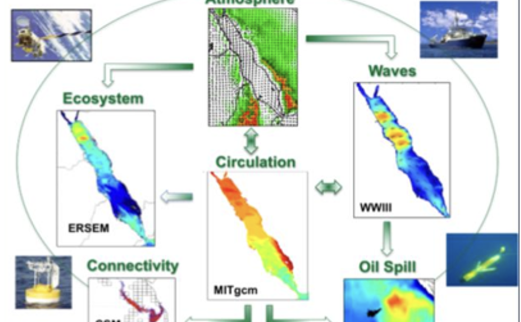
This project aims to build an integrated, automated operational system for real-time forecasting and visualization of ocean-atmosphere conditions in the Red Sea and Arabian Gulf. The system will assimilate remotely sensed and in situ data—such as satellite sea surface height and HF radar measurements—to produce up-to-date environmental forecasts. A key component is the development of a programming framework that automates the assimilation and forecasting processes, downscaling global atmospheric and oceanic data into high-resolution regional predictions. These include weather forecasts from the WRF atmospheric model (3–5 km resolution), ocean circulation from the MITgcm ocean model (1–2 km), and wave forecasts from the WAVEWATCH-III model (1 km), all of which will be forced by the assimilated WRF atmospheric conditions. The forecast outputs will be validated using mooring and HF radar measurements and run on KAUST’s supercomputing facility, SHAHEEN.
The system will also support near-real-time oil spill trajectory predictions through online queries accessible from ARAMCO headquarters. A powerful online visual analytics platform will be developed to allow interactive exploration of the forecasts, including atmospheric, oceanic, and wave data, as well as oil spill simulations. The system will be designed for use by both technical experts and non-specialists, ensuring usability across diverse stakeholders. By enabling real-time environmental monitoring, predictive scenario modeling, and user-friendly visualization, this operational platform will enhance regional marine risk management and support ARAMCO’s environmental protection strategies.